uk
uk en
enIELTS Map Model Essay
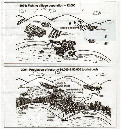
The diagrams below show the development of a small fishing village and its surrounding area into a large European tourist resort.
Summarize the information by selecting and reporting the main features, and make comparisons where relevant.
Sample answer
The maps illustrate how a little fishing village and its neighbourhood have changed over the period of time (since 1974) and turned into a big resort. In general, in 30 years, a small rural area near the sea has developed a lot: it increased in size; it was facilitated and built up with new buildings and roads. As a result, it has become a big popular tourist resort.
In 1974 the described area represented the fishing village in the south near the harbour and two small villages in the north at the foot of the mountains. Between them there were an olive garden and a woodland in the west; the flocks of sheep and goats were grazing on the vacant lands. The population of the fishing village was 12,000 people.
In 2004, the considerable changes and improvements were implemented: all the villages were connected with roads, the coast was built up with the big number of high-rise hotels. The original fishing village was preserved, which cannot be said about the harbour – there was created a beach on its place. The same fate befell the woodlands and olives – they turned into a golf course and a large farmland (which provides fresh fruit and vegetables for hotels) respectively. The small villages in the north also were improved and developed; in one of them tourist shops were opened.
Overall, the depicted area has turned into popular seaside resort, population of which has significantly grown (80,000 & 50,000 tourist beds). On the other hand, the original pristine nature was not remained.
Band score: 8.0